
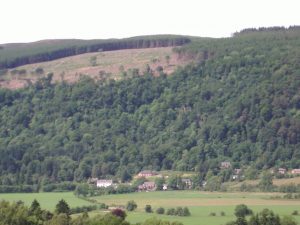
Weem village is situated a few hundred metres east of Castle Menzies in the picturesque Tay Valley, Perthshire, Scotland.
When attending a Clan Menzies Gathering most of the following landmarks and sights will be highly visible and accessible. Of interest are the vintage photographs of the area and Weem residents, helping to give insight to life in Weem both now and then.
PARISH OF WEEM
The first mention of Weem as a Parish is in Boiamund’s Taxatio, preserved in the Vatican.
In this record, popularly known as Bagimont’s Roll, is set out a list of parishes and tithes, collected from them in 1275 and 1276 by Boiamund de Vicci, Nuncio sent out by the Pope to gather funds for the relief of the Holy Land.
Among others, there is this entry : Ecclesia de Weem, 30 sols., giving revenue of 15 lib.
THE ROAD TO WEEM
In describing the route of General Wade’s approach to Weem it must be remembered that the town of Aberfeldy did not exist at the time.
Coming down the hill from the direction of Crieff, Wade made a bee-line for the site of Pitilie entering what is now “The Square” from the “Old Crieff Road”. He bridged the Moness Burn with a steep, hump-backed structure and then turned north-west to head for what is now known as “Wade’s Bridge”.
WADE’S BRIDGE
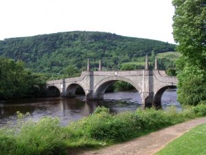
The bridge was constructed in 1733 to the design of architect William Adam, father of the better-known Robert Adam.
The material used was chlorite schist from a local quarry and the work was completed in nine months at a cost of £4,095-5s-10d.
Construction of the bridge was supervised by General Wade, born 1673, and he was reputed to have lodged at the Inn at Weem.
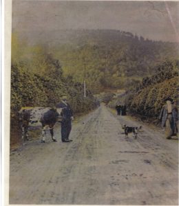
THE AVENUE – PAST
This stretch of road from Wade’s Bridge to Weem Toll was previously known as ‘The Hedges’, a name which recalls the time, 100 years ago and more, when it ran narrow and lane-like between hedges of beech, thorn, and brier, ten to twelve feet high on either side.
The Lombardy poplars which lined the present main road to Weem and made such a fine approach was planted by the late Sir Robert Menzies in 1897, the year of Queen Victoria’s Diamond Jubilee. This old photograph, above shows the poplar trees in their early stages of growth.
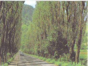
This photograph shows the Poplar Avenue prior to the unfortunate event which the Lombardy poplars suffered from a disease not dissimilar from Dutch Elm Disease and as a result had to be cut down and disposed of.
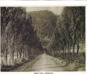
THE AVENUE – TODAY
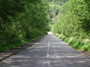
Following the removal of the diseased poplars from the ‘Avenue’, a renewal tree-planting operation was carried out a few years ago, with the introduction of new poplars – ‘The Whispering Aspens’ – and as the current photograph shows, has been successful, despite the annual flooding of the ‘Avenue’.
THE WEEM COW PARKS – NOW PART OF THE GOLF COURSE
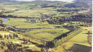
The independent companies of the Highland Watch camped on the Weem Cow Parks in May 1740, when they became embodied under the command of the Earl of Crawford as the 43rd Regiment of Foot and were to become the famous “42nd” The Black Watch Regiment
THE BLACK WATCH MONUMENT
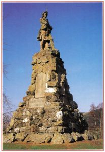
Close by Wade’s Bridge stands the Black Watch Monument. It takes the form of a massive cairn surmounted by a statue of Private Farquhar Shaw dressed in the original uniform of the Black Watch Regiment. The monument was unveiled in 1887 by the Marquis of Breadalbane to commemorate the first muster of the Regiment in May 1740. The muster took place on the Weem Cow Park on the north bank of the River Tay, in the Parish of Weem.
WEEM TOLL – PAST
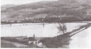
At the northern end of the “Poplar Avenue”, standing on the south side of the east-to-west road at Weem Toll, was the original Weem Toll House. This old photograph shows the Toll House during a severe flooding of the River Tay. Note that the Avenue here reflects the time when it was known as “The Hedges”
WEEM TOLL – PRESENT
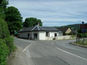
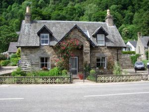
The original Weem Toll House, now a private residence, has been much improved and extended – and being adjacent to a road junction and tight bend on the main road, it is dangerously close to the fast-moving traffic of the present day.
WEEM TOLL JUNCTION – PAST
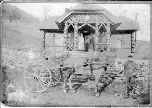
At the northern end of the “Poplar Avenue”, standing just across the east-to-west road at the Weem Toll on the north side, is a red-roofed cottage of the bungalow type. This was built about 100 years ago by the late Miss Egidea Menzies of Menzies as a saleroom for dairy products from the Castle Menzies Home Farm, and was known as “The Creamery”. Its life as such was short and for some years after was occupied by the District Nurse and renamed “Altramus”, the Gaelic for nursing.
The milkboy is James Menzies who went on to be estate joiner and keeper of the East Lodge for Lord Barnaby.
WEEM TOLL JUNCTION – PRESENT
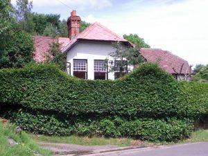
“Altramus”, was altered and extended some 50 years ago and is now a private residence. However, the name has been retained.
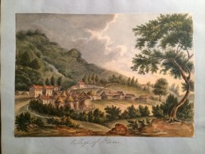
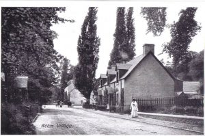
THE VILLAGE OF WEEM
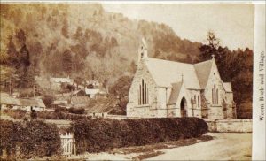
Weem, village and parish, in north-west Perthshire. The village stands on the Tay, about a mile north-west of Aberfeldy, and existed as long ago as 1235, and pre-dated Aberfeldy by about 500 years. The ancient village was previously known as Bail-a-Chlalchain nan Uamh (Kirktoun or Churchtown of Weem). The village was a centre of religious and economic importance. The Weem Hotel, a historic Inn, is said to date back to 1527. This was more than likely the base for General Wade during the 1733 construction of the bridge at Aberfeldy. The old church dates from around 1510 and was a place of worship until 1839 when it became the mausoleum of the Menzies family.
THE OLD ROAD FROM WEEM TOLL TO WEEM VILLAGE
The old high road (which can still be walked) runs from Weem Toll, up behind the present Ailean Chraggan Hotel, eventually passing the Manse and the old ParishSchool (now a ruin), the Schoolmaster’s house “Tigh-na-Sgoill”, and finally descends into Weem passing what used to be thatched cottages.
THE NEW ROAD FROM WEEM TOLL TO WEEM VILLAGE – PRESENT
In November 1778 the Presbytery of Dunkeld met to examine the glebe of the Minister at Weem on the proposal to cut a new road through the glebe, to take the place of the old high road which passed behind the manse. To compensate the minister, the glebe was extended to take in the field between the existing glebe and the canal just south of it.
“AILEAN CHRAGGAN”
Although the ‘Ailean Chraggan’ has been a hotel and restaurant for quite some time, it was originally built by the Menzies’ at the time of the building of St. David’s Chapel and was provided as a residence for the church organist.
THE FORMER MANSE OF WEEM
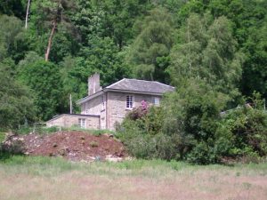
The former Manse of Weem was built in 1830 at the northern end of the glebe. It is understood that a previous Manse occupied this site, but the exact location is not known. The 1830 Manse is now privately owned.
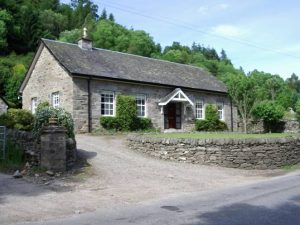
THE OLD PAROCHIAL SCHOOL
The old parochial school of Weem is situated some 150 yards up on the “old road” which ascends from the west side of the ParishChurch. The school was set up in 1665, and was eventually discontinued around the beginning of the 1900’s. The building is now a ruin, although the schoolbell-tower still stands. Unfortunately, due to the dense overgrowth, no photograph has been taken.
THE FORMER SCHOOL MASTER’S HOUSE
The school master’s house of Weem, now known as “Tigh-na-Sgoill”, which means ‘School House’, is situated some 100 yards up on the “old road” which ascends from the west side of the Parish Church. The old school house has been altered out of all recognition and is now occupied as a private house.
THE FORMER PARISH CHURCH FROM 1835 – 1921- PAST
With the eventual cessation of the Auld Kirk (St. Cuthbert’s) as a place of worship in 1839, Sir Neil Menzies had granted a site for a new Parish Church halfway between the old Toll House and Weem. This new church, erected in 1835, at a cost of some £700, and with seating for some 600 people was in use until July 1921, when it then became the Menzies Clan Society Hall. It was re-roofed in 1930, but subsequently fell into disrepair and was eventually demolished.
THE SITE OF THE FORMER PARISH CHURCH – PRESENT
The site of the old church was eventually purchased and the building demolished and following planning approvals a modern stone bungalow was built. As a requirement of the planning approval, part of the old church wall had to be incorporated as part of the building structure, and this was included at the rear of the building
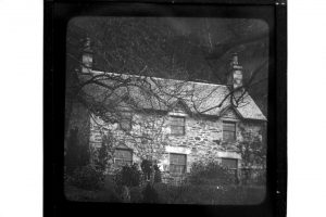
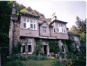
“CLEMATIS COTTAGE” – PAST
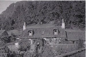
The home of the MacDonald Family for some four generations, this old photograph in 1913 shows the time when the roof was thatched.
SOME OLD RESIDENTS OF WEEM
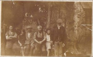
Can you recognise anyone in this group of people ? The village also supported a Brownie Group and a Gaelic Choir which were organised by the ministers wife.
WEEM ROCK PICNICS
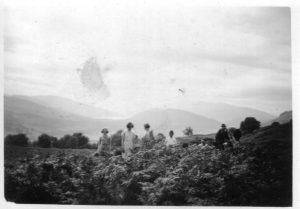
Picnics were held above Weem Rock by local families as shown by these photos of the Menzies Family from Boltachan in 1930’s
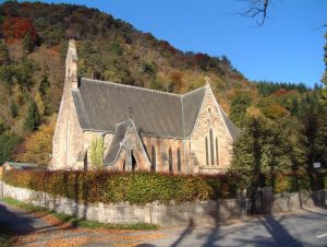
ST. DAVID’S CHAPEL – PAST & PRESENT
The church was built during the period 1868 to 1875 by Sir Robert Menzies of Menzies as St. David’s Episcopal Chapel for the Menzies family. After the death of the last of the Menzies of Weem line in 1918 and the break up of the estate, the chapel was acquired by the Church of Scotland in 1921 as the new Parish Church of Weem.
THE WAR MEMORIAL
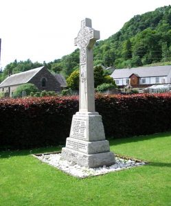
The War Memorial, in the form of an Iona Cross, stands to the south west of the doorway to the present Parish Church and was erected to commemorate the local men who gave of their lives during the Great War of 1914 to 1919. “Their fame alone has returned”. For more information on war memorial click here.
THE SITE OF AN OLD VILLAGE WELL
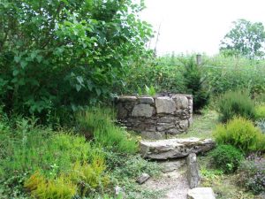
During the construction of the MacDonald Room and Vestry of the Parish Church in 1993/1994, an old Village Well of Weem was rediscovered and has now been fully restored and can be seen at the north east corner to the rear of the Parish Church.
ST. CUTHBERT’S CHURCH – THE MENZIES MAUSOLEUM
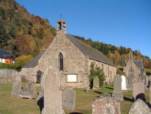
The Pre-Reformation Church is dedicated to St. Cuthbert and mentioned in charters dated 1235. The present building probably dates from 1510 and was a place of worship until 1839 when it became the mausoleum of the Menzies family. It contains all that is mortal of all the Menzies chiefs and on the walls hang the Hatchments bearing a representation of the Arms of each Knight.
LOOKING WEST TO THE WEEM HOTEL- PAST
The view of Weem looking west towards the Weem Hotel. Probably taken around the 1920s or ’30s.
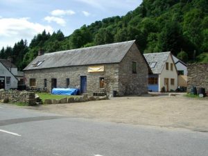
THE OLD BLACKSMITH’S SHOP AND
Although now no longer the smithy, but part of the outbuildings of Weem Farm, nobody seems to know how old the smithy is, but it is supposed to have been the forge of Andreas Ferrara, the great 16th-century swordmaker. Certainly, it is known that he had his smithy hereabouts.
THE OLD BLACKSMITH’S COTTAGE
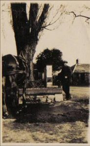
THE OLD VILLAGE WELL – PAST
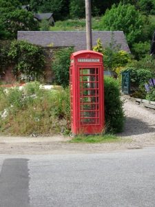
THE SITE OF THE OLD VILLAGE WELL – PRESENT
What was once the village well is now the familiar red telephone box
THE SITE OF THE OLD WEEM THEATRE
Now a Bunkhouse development, this was the site, originally of the old Weem Theatre, then lock-up garages for the Weem Hotel and subsequently a garage.
WADE’S HOUSE
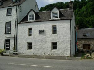
Attached to the Weem Hotel, is the house that General Wade had made his headquarters during the construction of the bridge over the River Tay, south-east of Weem.
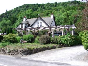
THE WEEM HOTEL – PAST
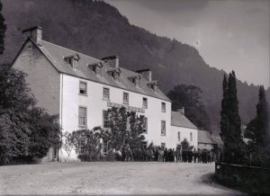
This popular and historic inn is said to date back to 1527. Over the years it has been extended and the oldest part, Wade’s House, in which General Wade lived during the construction of the Bridge, used to form the Public Bar of the Hotel.
The past photograph was probably taken during the 1950’s and shows the late Donald Matheson, the proprietor of the Weem Hotel at the time, playing the pipes outside the Hotel.
THE WEEM HOTEL – PRESENT
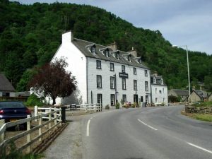
This popular and historic inn has been extended over the years and the oldest part, Wade’s House in the east wing, is now part of
the recently constructed Bunkhouse development.
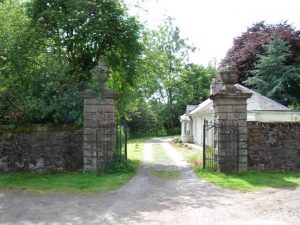
THE EAST GATE TO CASTLE MENZIES-
PAST
Beside Weem Hotel is the East Gate to the policies of Castle Menzies, ancient home of the Chiefs of the Clan, and just inside, beyond the lodge, there hung for many years high up in one of the trees a bell which used to be rung to warn the people at the Castle of the approach of visitors. It was set there by Sir John and Lady Menzies in the year 1790.
PRESENT
THE OLD VILLAGE CURLING POND
Having past through the East Gate of Castle Menzies, and just inside, to the left beyond the lodge, is the original Curling Pond of Weem – although no longer used for many years. The Perthshire Courier of March 24th 1885, reported that “Sir Robert Menzies, Bart., entertained the members of the Weem Curling Club at Farleyer on Friday night, when he was presented with a beautifully-illuminated address, silver tee, and pair of Crawfordjohn curling stones with ebony silver-mounted handles. The formal presentation had to be postponed owing to the death of Mr. Butter of Faskally.”
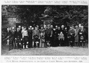
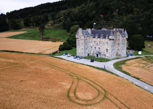
CASTLE MENZIES- PAST
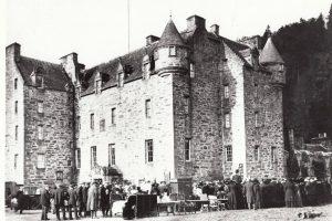
The castle lies a few hundred metres west of Weem village and shares its entrance with the access road to Weem Rock car park. The castle was built to replace a mansion house – ‘The Place of Weem’ – which had been pillaged and burned in 1502/1503. The date of foundation is uncertain but it must have been before 1577 because it was then that the dormers and pediments on the upper storey are known to have been added. The building is a fine example of a Z-plan tower house.
– PRESENT
THE WALLED GARDEN OF THE CASTLE- PAST
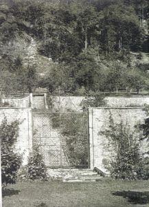
This gate leads to the walled garden of Castle Menzies which is thought to date from around the 18th century. The parkland was laid out between 1823 and about 1860 and the surrounding woodland was established during the early 19th century.
THE WALLED GARDEN OF THE CASTLE- PRESENT
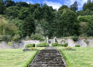
The grounds, including Weem Rock, are famous for their trees and it is said that they contained every known species of Pine Tree. Most of them were planted by Sir Robert, the third Baronet.
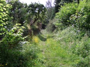
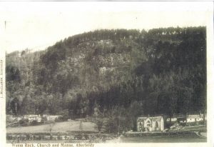
WEEM ROCK
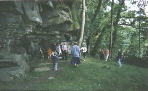
From the car park, reached via the main entrance to Castle Menzies, the Forestry Commision has constructed a path which gives access to the steep, tree-clad fastness of the Rock. This path leads to St. David’s Well and Cave. Those who venture to the highest point of the Rock can visualise its former importance to the Clan Menzies as the site for a beacon to warn of the approach of an enemy.
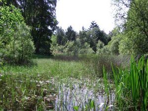
ST. DAVIDS WELL
St. David’s Well is ascribed to Sir David Menzies who, in the 15th century, used the place as a retreat from worldly concerns. In the past it has been used as a wishing well but forestry development on the hill above has prevented surface water from reaching underground water courses and so the Well is often dry.
Even further back in history the Well was known as Fuaran Creig a’Chaibel (Chapel Rock Well) and is attributed to the work of St. Cuthbert who built a wooden oratory here during his missionary journeys through Scotland in the 7th century.
THE CAVE
The Cave, in which St. Cuthbert probably sheltered and from which the village took its name, is situated almost directly beneath the Well and is difficult to reach. Legend has it that the Cave used to extend to Loch Glassie, nearly two miles away and some 650 feet higher.
*The Aberfeldy Museum Group has been created to campaign and work for the establishment of a museum in Aberfeldy, dedicated to preserving the town’s history.